False Creek is a saltwater inlet that cuts through the middle of Vancouver, separating Yaletown and downtown from the neighbourhoods on the south side. It is not a creek — the tidal channel was partially filled during the twentieth century, and what remains is about two kilometres of open water running from Science World in the east to the mouth near the Burrard Bridge in the west. The Seawall traces the full perimeter. Mini-ferries cross it every fifteen minutes. The result is one of the most walkable and transit-friendly areas in the city, and a reasonable destination in itself rather than just a route between other places.
This guide covers the Seawall loop, the ferry options, the neighbourhoods on each shore, the parks, eating, and how to move through the area without a car.
The Seawall loop
The False Creek section of the Vancouver Seawall runs along the south shore from Science World at the east end to Granville Island at the west end, roughly three kilometres. The path is flat, paved, and shared between cyclists and pedestrians — marked lanes, though traffic varies significantly between weekday mornings and summer weekend afternoons.
The east end starts at the plaza around Science World, the geodesic dome that has anchored this corner of False Creek since Expo 86. The building is the paid attraction; the plaza and the waterfront path around it are free and worth walking regardless. Looking west from Science World you have the whole creek in view, with BC Place visible on the north shore in the distance.
Walking west, the path passes through Olympic Village — a neighbourhood of mid-rise residential buildings and ground-floor restaurants developed on the south shore after the 2010 Winter Olympics. The waterfront here has benches, open space, and a view back toward Science World and the Cambie Bridge that is one of the better free viewpoints in the city.
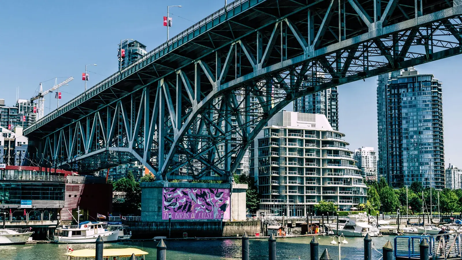
Continuing west, the path passes under the Cambie Bridge, then the Granville Bridge, before reaching Granville Island at the western end. The full south-shore walk from Science World to Granville Island takes 40 to 50 minutes at a relaxed pace.
The north shore — Yaletown and the area near BC Place — has its own Seawall path, shorter and more urban. If you want the full loop, cross at either end using bridges or take a ferry across.
The mini-ferries
Two operators run small passenger ferries across and along False Creek: Aquabus and False Creek Ferries. Both run continuously through the day. Neither requires advance booking.
Aquabus stops include Granville Island, the Hornby Street dock in downtown Vancouver, David Lam Park in Yaletown, Stamp’s Landing, and Science World. False Creek Ferries connects Granville Island with the Aquatic Centre dock on Beach Avenue, Science World, and Vanier Park near the Maritime Museum.
The practical use of the ferries is twofold: they let you cross the creek without adding a kilometre of walking, and they turn a functional transit trip into part of the experience. A crossing takes five to eight minutes. The views of the creek, BC Place, and the downtown skyline from the water are better than from any bridge.
Fares vary by route and operator. Day passes are available from both if you plan to cross multiple times. Check current pricing on each operator’s website before you go — fares change seasonally.
Olympic Village
The Olympic Village neighbourhood sits on the south shore between the Cambie Bridge and Main Street–Science World SkyTrain station. Built as the athletes’ village for the 2010 Winter Olympics and converted to residential and commercial use afterward, it has good bones — wide waterfront paths, coherent architecture, and a concentration of restaurants and cafes within a small area.
The waterfront plaza is the social centre of the neighbourhood. On summer afternoons it fills with people eating, watching the creek, and waiting for ferries. The restaurants facing the water tend toward mid-range pricing.
The Olympic Village SkyTrain station on the Canada Line is about eight minutes from downtown Vancouver. For a south shore start to the False Creek walk, this is the easiest transit entry point.
Parks on the creek
Several parks sit along the False Creek shoreline and are free year-round.
Coopers’ Park occupies the south shore just east of the Cambie Bridge. It is a small waterfront park with lawns, benches, and direct views across the creek to Yaletown. It connects directly to the Seawall on both sides. On weekday mornings it is quiet; summer afternoons draw people from the surrounding residential towers.
David Lam Park sits on the north shore in Yaletown, between the Cambie and Burrard bridges. Larger than Coopers’, it has an open lawn area, waterfront access, and an Aquabus stop at the dock. It is well used by Yaletown residents but accessible to anyone on the north shore path.
For a free outdoor stop that connects easily to a ferry crossing, either park works — Coopers’ if you are walking the south shore, David Lam if you are on the north side or arriving from downtown.
Wildlife on the creek
False Creek is more active with wildlife than its urban setting suggests. Great blue herons are a constant presence along the shoreline — they stand motionless at the water’s edge near the parks and ferry docks, fishing the shallows, and are close enough to observe without any effort. The stretch near Coopers’ Park and the ferry stops at Stamp’s Landing tends to have the most regular heron sightings.
Harbour seals appear in the creek periodically, particularly in the spring and early summer when small fish move through the inlet. They are visible from the Seawall and from the ferries — a crossing on a calm morning sometimes brings you within fifteen metres of one. Seal sightings are not guaranteed but are common enough that they are worth watching for rather than surprising.
Cormorants use the pilings and dock structures along the creek, spreading their wings to dry in the characteristic posture that makes them easy to identify from a distance. Canada geese and various duck species are present year-round on the water. In spring, the eastern end near Science World sees the most bird activity, partly because the water is shallower and more protected there.
Granville Island
Granville Island sits under the Granville Bridge on the south shore, connected by a short causeway or by ferry. The Public Market is the main draw — a year-round indoor market with produce, fish, prepared food, and specialty vendors. It is busy on weekend mornings and genuinely crowded in summer. Weekday mornings before 10am are significantly calmer.
Beyond the market, the island has working studios and galleries, a brewery, restaurants on Johnston Street, and the Emily Carr University campus. The perimeter is walkable in twenty minutes.
For a detailed breakdown of what to buy and how to avoid the worst of the weekend crowds, the Granville Island guide covers the specifics.
BC Place and the north end
BC Place sits on the north shore at the west end of False Creek, accessible from the north shore Seawall or by ferry from Granville Island. Outside of events it is a landmark rather than a destination — the retractable roof and scale of the stadium are visible from most of the creek, but the area between events is largely commercial and transit-focused.
Rogers Arena is a short walk east. The two venues together make this end of the creek the highest-traffic area on event days. On non-event days, the north shore Seawall between the two arenas is one of the quieter stretches of the whole loop. The plaza area around BC Place also connects directly to the north shore Seawall path, making it a natural turning point if you are walking from Granville Island eastward along the north side.
Eating along False Creek
The price range for eating near False Creek varies by location.
Granville Island is the most flexible. The Public Market has prepared food at various price points, from a quick bowl to a proper sit-down lunch, and the food stalls inside are faster and less expensive than the island’s restaurants.
Olympic Village has the highest concentration of sit-down restaurants, running from casual cafes to mid-range waterfront dining. The cafes in the Olympic Village square are the lower-cost option for coffee and a stop mid-walk.
The Science World and east end have the fewest food options directly on the creek. If you are starting from that end, eat before you arrive or plan to walk west to Olympic Village before stopping.
For eating near BC Place specifically — before a match or an event — the restaurants near BC Place guide covers the options by distance and price.
Getting there
False Creek is well served by transit from multiple directions.
Canada Line: Olympic Village Station puts you on the south shore roughly midway along the creek. From downtown Vancouver the ride is eight minutes. From YVR airport it is about fifteen.
Expo Line: Main Street–Science World Station sits at the east end of False Creek, directly beside Science World. From downtown this is a six-minute ride. This is the best starting point if you want to walk the south shore Seawall from east to west and finish at Granville Island.
Bus: several routes serve the False Creek area, including service along Broadway and West 4th Avenue on the south side. Check TransLink for the best route from your starting point.
On foot from downtown: the north shore Seawall path south through Yaletown connects to the north side of False Creek. The walk from downtown to Granville Island via the north shore takes about 35 to 45 minutes.
By bike: Mobi bike share has stations near Olympic Village and at several points along the False Creek Seawall. The cycling lane on the south shore path connects most of the main stops without needing to leave the waterfront. For visitors who want to cover more ground than a walk allows — from Science World to Granville Island and back, for instance — a Mobi day pass is a practical option. The terrain is flat the entire way.
Parking
Parking along False Creek is the weakest option for most visits.
Granville Island has a paid lot that fills by mid-morning on summer weekends. Olympic Village has metered commercial parking that is competitive on weekends. The Science World end has some street parking along Quebec Street, but summer Saturday mornings fill it early.
The transit connections are good enough that driving to False Creek, rather than to a SkyTrain station, is rarely worth the stress on a busy day.
When to go
False Creek works in every season, but the experience changes between summer and the rest of the year.
May through September: the Seawall is busy on summer weekends, particularly between Granville Island and Olympic Village. The waterfront restaurants fill up by noon. The ferries have short waits. Weekday mornings before 10am give you the same views with a fraction of the pedestrian traffic.
October through April: the creek is quieter, the restaurants are less crowded, and the Seawall is mostly locals. The Granville Island Public Market is worth visiting in shoulder season specifically because tourist volume drops significantly. Rain is the variable — Vancouver’s fall and winter bring overcast days with occasional heavy rain, and the Seawall is exposed along most of its length. A dry winter afternoon on False Creek, with the mountains visible behind the downtown skyline, is one of the better free things the city offers.
If you are trying to avoid crowds entirely, the shoulder weeks in May and September are the best combination of good weather and manageable visitor numbers. The ferries are running on full schedules, the Public Market is stocked for the season, and the Seawall does not require navigating around weekend tourist volume. The difference between a Saturday in August and a Tuesday in September on this stretch of the Seawall is significant.
For more free and low-cost options across the city, the free and cheap things to do in Metro Vancouver guide has the broader list.